 |
| credit: Cameron Baccario |
Showing posts with label earth. Show all posts
Showing posts with label earth. Show all posts
Tuesday, January 21, 2014

Friday, August 9, 2013
What Pangaea Would Look Like With Today's Political Boundaries
About 300 million years ago, the supercontinent of Pangaea started to break apart into the continents we live on today. An Italian designer—who goes by the name Massino—put Pangaea back together, then added on modern political boundaries. This created the map you see below:
 |
| Political Pangaea via Massino |
Monday, April 29, 2013
I Spy: Space Edition
The first mission to the International Space Station, a habitable artificial satellite orbiting four hundred kilometers above the Earth's surface, launched over twelve years ago. Since then, astronauts have taken an astonishing million plus photographs of their home planet. So what happens to all these photos?
Turns out they're all archived on NASA's servers and are available to the public for view. Nathan Bergey combed through that archive and pulled the location for all of those 1,129,177 photos. He's created an incredible visual with this data:
This visualization of the data ends up depicting the basic shapes of the continents, which makes sense as astronauts tended to take pictures of where they were from. Nathan comments that, "Coastlines, islands and cities seem to be popular targets...This makes sense, photos of clouds over an otherwise blank ocean get old after a while."
After creating this visualization, he ended up dividing the dots by mission:
If you're wondering why the purple dots seem to overwhelm the rest of the image, it's because Don Pettit took multiple time lapse sequences—each consisting of hundreds of images—on his mission. His images cause almost uninterrupted orbit lines while the rest of the dots seem to come in randomly. Fun fact: Don Pettit is solely responsible for almost half the images taken in orbit!
If you're interested in more data and what else NASA has to offer, check out data.nasa.gov, International Space Apps Challenges, and spacehack.org.
Turns out they're all archived on NASA's servers and are available to the public for view. Nathan Bergey combed through that archive and pulled the location for all of those 1,129,177 photos. He's created an incredible visual with this data:
 | |
| Each dot represents the location of a photo. |
After creating this visualization, he ended up dividing the dots by mission:
 | |||||||
| Each color represents a different mission. |
If you're wondering why the purple dots seem to overwhelm the rest of the image, it's because Don Pettit took multiple time lapse sequences—each consisting of hundreds of images—on his mission. His images cause almost uninterrupted orbit lines while the rest of the dots seem to come in randomly. Fun fact: Don Pettit is solely responsible for almost half the images taken in orbit!
If you're interested in more data and what else NASA has to offer, check out data.nasa.gov, International Space Apps Challenges, and spacehack.org.
Monday, April 1, 2013
Wise Up! April Fools' from the Science Community
Pranking people is a grand tradition that dates back to
who-knows-when, and science pranks for April 1st are no exception.
Since the average reader is perhaps quite liable to believe what
they read, scientists are at an advantage on this day. After all, who expects a
boring scientist to have a sense of humor?
Below are some of the best April Fools' pranks perpetuated by the science community:
1959: Dr. Arthur
Hayall—not a real person—from University of the Sierras—not a real place—claimed
that the moons of Mars were actually artificial satellites. The rumor ran that
the Martians were using the satellites as bases.
1974: John Gribbin published The Jupiter Effect, which stated that the Grand Alignment of planets meant that Armageddon would arrive on March 10th, 1982. (Spoiler: It didn’t.)
1976: BBC Radio 2 astronomer Patrick Moore announced that at 9:47 a.m. that day, Pluto would pass directly behind Jupiter and their combined gravitational forces would combine to lessen Earth’s gravity. He helpfully hinted that listeners jump into the air at that time to experience less gravity and increasing their buoyancy.
1996: Discover Magazine announced the discovery of a “bigon,” a new fundamental particle of matter that appears and disappears in mere millionths of a second, and also happened to be the size of a bowling ball. Everything from sinking soufflés to spontaneous human combustion was blamed on the bigon.
1998: Nature reported a “near-complete skeleton of a theropod [T. rex-like] dinosaur in North Dakota”— which was implicitly suggested to have breathed fire—discovered by Randy Sepulchrave of the Museum of the University of Southern North Dakota. Of course there is no University of Southern North Dakota and the skeleton, dubbed Smaugia volans, derived its name from Tolkien’s The Hobbit. Furthermore, Sepulchrave is a famous fictional character who believed he was an owl and died in a dramatic attempt to fly from a high tower.
1999: The Red Herring Magazine published an article on how users could, through a technology developed by computer genius Yuri Maldini, send emails telepathically of up to 240 characters. The magazine received numerous letters from intrigued readers.
2004: Google announced that they were opening their Copernicus Center, which would be a “lunar hosting a research” site. Applicants need not apply if they couldn’t live without “modern conveniences as soy low-fat lattes, The Sopranos and a steady supply of oxygen.”
2005: The day before April Fools’, NASA’s Astronomy Picture of the Day contained a teaser announcement “Water on Mars!” The photo ended up depicting a glass of water sitting on a Mars bar, and now the idea that there might actually be water on the red planet doesn’t seem so silly after all.
2008: The BBC claimed to have discovered a colony of flying penguins and released footage, narrated by Monty Python’s Terry Jones in a David Attenborough-esque manner. (Watch the video here.)
2012: A mock study titled “On the influence of the Illuminati in astronomical adaptive optics” (pdf warning) described how the nefarious shadow cult is to blame for pretty much everything, including Brittney Spears’ and Lady Gaga’s “astronomical rise to the top.”
Below are some of the best April Fools' pranks perpetuated by the science community:
 |
| Google's Copernicus Center |
1974: John Gribbin published The Jupiter Effect, which stated that the Grand Alignment of planets meant that Armageddon would arrive on March 10th, 1982. (Spoiler: It didn’t.)
1976: BBC Radio 2 astronomer Patrick Moore announced that at 9:47 a.m. that day, Pluto would pass directly behind Jupiter and their combined gravitational forces would combine to lessen Earth’s gravity. He helpfully hinted that listeners jump into the air at that time to experience less gravity and increasing their buoyancy.
1996: Discover Magazine announced the discovery of a “bigon,” a new fundamental particle of matter that appears and disappears in mere millionths of a second, and also happened to be the size of a bowling ball. Everything from sinking soufflés to spontaneous human combustion was blamed on the bigon.
1998: Nature reported a “near-complete skeleton of a theropod [T. rex-like] dinosaur in North Dakota”— which was implicitly suggested to have breathed fire—discovered by Randy Sepulchrave of the Museum of the University of Southern North Dakota. Of course there is no University of Southern North Dakota and the skeleton, dubbed Smaugia volans, derived its name from Tolkien’s The Hobbit. Furthermore, Sepulchrave is a famous fictional character who believed he was an owl and died in a dramatic attempt to fly from a high tower.
1999: The Red Herring Magazine published an article on how users could, through a technology developed by computer genius Yuri Maldini, send emails telepathically of up to 240 characters. The magazine received numerous letters from intrigued readers.
2004: Google announced that they were opening their Copernicus Center, which would be a “lunar hosting a research” site. Applicants need not apply if they couldn’t live without “modern conveniences as soy low-fat lattes, The Sopranos and a steady supply of oxygen.”
2005: The day before April Fools’, NASA’s Astronomy Picture of the Day contained a teaser announcement “Water on Mars!” The photo ended up depicting a glass of water sitting on a Mars bar, and now the idea that there might actually be water on the red planet doesn’t seem so silly after all.
2008: The BBC claimed to have discovered a colony of flying penguins and released footage, narrated by Monty Python’s Terry Jones in a David Attenborough-esque manner. (Watch the video here.)
2012: A mock study titled “On the influence of the Illuminati in astronomical adaptive optics” (pdf warning) described how the nefarious shadow cult is to blame for pretty much everything, including Brittney Spears’ and Lady Gaga’s “astronomical rise to the top.”
Wednesday, March 27, 2013
Celestial Sightings
Just about every evening before going to bed, I take a moment to look at the
stars. While the weather isn’t always agreeable, when it’s clear there’s always
something worth seeing. Last Sunday, for example, there was the beautiful
sight of Jupiter and the neighboring crescent moon closely paired together.
Tomorrow night, be on the lookout for the waning moon (after all, yesterday was the worm moon — the first full moon in March) sandwiched between Spica and Saturn. You will be able to find the moon midway between the star and the planet, which are currently 17° apart.
Spica will be the white star to the moon’s upper right and Saturn will be more creamy-colored down to the moon’s lower left. Because such a full moon would usually wash out anything in its near vicinity, this degree of separation will actually help the casual observer spot the trio. It will be easiest to spot this celestial arrangement in the southeast after 11 p.m.
Tomorrow night, be on the lookout for the waning moon (after all, yesterday was the worm moon — the first full moon in March) sandwiched between Spica and Saturn. You will be able to find the moon midway between the star and the planet, which are currently 17° apart.
Spica will be the white star to the moon’s upper right and Saturn will be more creamy-colored down to the moon’s lower left. Because such a full moon would usually wash out anything in its near vicinity, this degree of separation will actually help the casual observer spot the trio. It will be easiest to spot this celestial arrangement in the southeast after 11 p.m.
 |
Spica is the brightest star in the
constellation Virgo
Light from the moon, reflected from the sun, takes only 1.25 seconds to
reach the earth. The light from Saturn, 830 million miles away, takes about 74
minutes. However, the light from Spica, a 1st magnitude blue giant,
takes about 260 years to finally reach our eyes. So be aware that the light
you'll see left the brilliant star well before the American Revolution.
For more on lunar occulations — and the best time to see this trio in
your area — check out details here.
Saturday, August 11, 2012
Moon Disaster
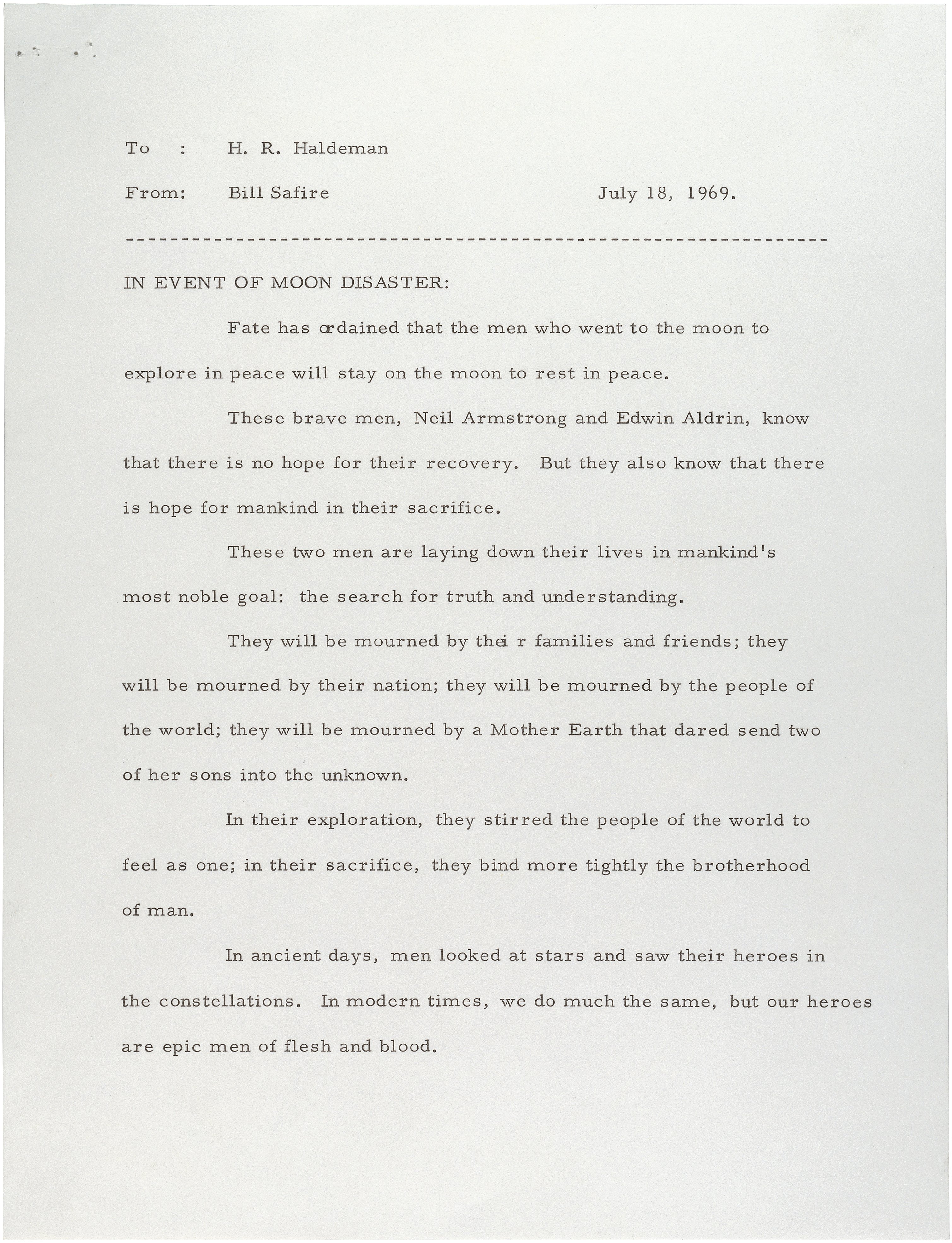
This is the first page of a speech written by Bill Safire for President Nixon to read if the moon landing went poorly and the astronauts were unable to return. As we know, thankfully it was unnecessary but it's still a poignant insight into the fears and uncertainty of space exploration.
Saturday, June 30, 2012
Leap Second: Today is the Longest Day of the Year
Due to the gradual slowdown in Earth's rotation, a team at the Paris Observatory is adding a "leap second" just before
midnight. Experts
at the International Earth Rotation and Reference System Service make
the adjustment when the planet's movement falls out of sync with atomic
clocks used to measure time.
"Today, time is constructed defined and measured with atomic clocks" said Noel Dimarcq, director of the SYRTE time-space reference system at the Paris Observatory. "This allows us to ensure that everyone on Earth is on the exact same time," Daily Mail quoted Dimarcq as saying.
Today's final minute (Greenwich Time), with its added second, will compensate for the sloshing of oceanic tides on the continental shelves, which slows Earth's rotation ever so slightly. It's been four years since a leap second has been added.
"Today, time is constructed defined and measured with atomic clocks" said Noel Dimarcq, director of the SYRTE time-space reference system at the Paris Observatory. "This allows us to ensure that everyone on Earth is on the exact same time," Daily Mail quoted Dimarcq as saying.
Today's final minute (Greenwich Time), with its added second, will compensate for the sloshing of oceanic tides on the continental shelves, which slows Earth's rotation ever so slightly. It's been four years since a leap second has been added.
Friday, May 18, 2012
Rare Annular Eclipse
A rare "annular eclipse" of the Sun will occur in our area (northern California) in the late afternoon of May 20, 2012. I encourage you to see it, regardless of whether you can be within the narrow path where the "ring of fire" will be visible. (You will at least see a deep partial eclipse of the Sun, if you are in the western US.)

An annular solar eclipse occurs when the Sun, Moon, and Earth are lined up, but the Moon is farther than average from Earth, so it looks a bit too small to fully cover the Sun. Thus, if you are at one of the right places (see the below map), the Sun will form a ring, or annulus, around the Moon. It's a special form of a partial solar eclipse that's cool to see (though not nearly as dramatic and mind-blowing as a total solar eclipse). You can view a map showing the eclipse path in detail here.
Online, you can zoom in on it and find specific locations from which the eclipse will be visible. Click on the location to find times, etc. Note that "UT" is "Universal Time" (the time in Greenwich, UK), and right now it is 7 hours ahead of PDT. So, for example, I find that in northern CA, the middle of the eclipse will occur around 6:28 pm PDT on May 20 (1:28 am UT on May 21), and the annular phase will last about 4.5 minutes if you are near the "centerline." (Note: the non-annular partial phases will last much longer, a couple hours total: 5:20 pm to 7:34 pm, plus or minus a few minutes, depending on exactly where you are.)
The centerline (from which the Moon will appear perfectly centered on the Sun at mid-eclipse) is the orange curve, and the blue lines mark the northern and southern edges of the path of annularity; outside the blue lines, you'll see a partial solar eclipse but not a complete annulus or ring. So, try to go to a favorable location, within the brown swath. Choose your location wisely! You can find a summary graph that shows the percent cloudiness along the path here.
Oroville in CA (near Chico) has great odds, it seems: just 11% cloudiness. But it isn't super close to the centerline; Redding and Mt. Shasta are closer, but have somewhat worse odds. If you are between the two red lines, you'll see a complete "ring of fire." Outside that band, you'll see a partial eclipse, but not a full ring. You don't have to be right on the centerline, by the way -- just within the swath, if you want to see the "ring of fire," though it will last longer if you are closer to the centerline.
More info about weather patterns is given here at the following websites:
http://home.cc.umanitoba.ca/~jander/ase2012/ase12intro.htm
http://home.cc.umanitoba.ca/~jander/ase2012/climate.htm
Have fun viewing the annular eclipse, but be sure to view it safely! And if you can't get to the path of annularity (the brown swath in the map), at least view the regular partial eclipse from wherever you happen to be at the time (late afternoon on May 20), if it's visible.
An annular solar eclipse occurs when the Sun, Moon, and Earth are lined up, but the Moon is farther than average from Earth, so it looks a bit too small to fully cover the Sun. Thus, if you are at one of the right places (see the below map), the Sun will form a ring, or annulus, around the Moon. It's a special form of a partial solar eclipse that's cool to see (though not nearly as dramatic and mind-blowing as a total solar eclipse). You can view a map showing the eclipse path in detail here.
Online, you can zoom in on it and find specific locations from which the eclipse will be visible. Click on the location to find times, etc. Note that "UT" is "Universal Time" (the time in Greenwich, UK), and right now it is 7 hours ahead of PDT. So, for example, I find that in northern CA, the middle of the eclipse will occur around 6:28 pm PDT on May 20 (1:28 am UT on May 21), and the annular phase will last about 4.5 minutes if you are near the "centerline." (Note: the non-annular partial phases will last much longer, a couple hours total: 5:20 pm to 7:34 pm, plus or minus a few minutes, depending on exactly where you are.)
The centerline (from which the Moon will appear perfectly centered on the Sun at mid-eclipse) is the orange curve, and the blue lines mark the northern and southern edges of the path of annularity; outside the blue lines, you'll see a partial solar eclipse but not a complete annulus or ring. So, try to go to a favorable location, within the brown swath. Choose your location wisely! You can find a summary graph that shows the percent cloudiness along the path here.
Oroville in CA (near Chico) has great odds, it seems: just 11% cloudiness. But it isn't super close to the centerline; Redding and Mt. Shasta are closer, but have somewhat worse odds. If you are between the two red lines, you'll see a complete "ring of fire." Outside that band, you'll see a partial eclipse, but not a full ring. You don't have to be right on the centerline, by the way -- just within the swath, if you want to see the "ring of fire," though it will last longer if you are closer to the centerline.
More info about weather patterns is given here at the following websites:
http://home.cc.umanitoba.ca/~jander/ase2012/ase12intro.htm
http://home.cc.umanitoba.ca/~jander/ase2012/climate.htm
Have fun viewing the annular eclipse, but be sure to view it safely! And if you can't get to the path of annularity (the brown swath in the map), at least view the regular partial eclipse from wherever you happen to be at the time (late afternoon on May 20), if it's visible.
Monday, May 7, 2012
Map it out: An Interactive Map of the World
This morning I found a cool site featuring an interactive map called the Antipodes Map. What you can do is find your home (or any other place on the map) and the map will show its antipode - meaning the spot on the earth of which it is diametrically opposite. As the site explains, "Two points which are antipodal to one another are connected by a straight line through the centre of the Earth."
Therefore, if you click on, or move the original map, you can set a marker on a desired location. The antipode map will automatically show its antipodal location. So what can you use this for? Well, most importantly, it will show you where if you dug straight through the earth you'd end up (provided of course you were able to withstand all the radiation, heat, and intense compression you would experience).
Therefore, if you click on, or move the original map, you can set a marker on a desired location. The antipode map will automatically show its antipodal location. So what can you use this for? Well, most importantly, it will show you where if you dug straight through the earth you'd end up (provided of course you were able to withstand all the radiation, heat, and intense compression you would experience).
Tuesday, April 24, 2012
Planet Earth
In anticipation of Planet Earth's return to BBC America, this video was released featuring young fans reading scripts and voicing over action on the screen. These are supposed to be narrator auditions for the Planet Earth series, and some of their youngest fans decide to try their hand at relaying wilderness scenes. However, Sir David Attenborough - the regular narrator - is a tough act to follow, even for kids. The results are hysterical.
Monday, February 6, 2012
The Earth at Night

This is an image of the world at night, thanks to NASA's Visible Earth, 2001. The various colors that can be seen are city lights, natural gas flares, wildfires, and lights from fishing fleets. (Disclaimer: Obviously, this is a compiled image since the earth is never all dark at once, nor is it flat...)
Subscribe to:
Posts (Atom)